
Seawater Temperature, Conductivity & Salinity
Instrument Type: Sea-Bird SBE37 SIP
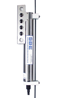 Installed: October 2013 - present
Description: Temperature is acquired by applying an AC excitation to a bridge circuit containing an ultra-stable aged thermistor and VISHAY precision resistors. Conductivity is acquired using an ultra-precision Wein-Bridge oscillator to generate a frequency output in response to changes in conductivity. Salinity values are calculated from the 1978 Practical Salinity Scale Equations.
Location: Approx. 1 km south of Hog Island in Tomales Bay at a depth of ~1 m
Latitude 38° 11' 16.26” N
Longitude 122° 55' 39.65" W
Specifications: Temperature
Range: -5 to +35 deg C
Res: 0.001 deg C
Acc: 0.002 deg C
Specifications: Conductivity
Range: 0 to 9 S/m
Res: 0.0005 S/m
Acc: 0.0003 S/m
Acquisition Settings:
Sample Interval: 10 minutes
Pump installed
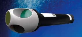
Chlorophyll Fluorescence, Turbidity, and Backscattering Data
Instrument Type: Wetlabs ECO-FLNTU (combination chlorophyll fluorescence and turbidity meter)
 Installed: October 2013 - present
Description: The Environmental Characterization Optics or ECO miniature fluorometer allows the user to measure relative chlorophyll concentrations by directly measuring the amount of fluorescence emission in a sample volume of water. The ECO uses an LED to provide the excitation source. An interference filter is used to reject the small amount of out-of-band light emitted by the LED. The light from the source enters the water volume at an angle of approximately 55 – 60° with respect to the end face of the unit. Fluoresced light is received by a detector positioned where the acceptance angle forms a 140° intersection with the source beam. An interference filter is used to discriminate against the scattered excitation light.
To determine turbidity, the unit simultaneously emits light at 700nm and subsequently detects how much of that light is scattered by particles in the water.
Location: Approx. 1 km south of Hog Island in Tomales Bay at a depth of ~1 m
Latitude 38° 11' 16.26” N
Longitude 122° 55' 39.65" W
Specifications: Fluorometer
Excitation Wavelength: 470 nm
Emission Wavelength: 695 nm
Range: 0-50 ug/L
Acc: 0.2% Factory Standard (FS) ug/L
Prec: 0.04% FS ug/L
Linearity: 99% R2
Specifications: Turbidity
Wavelength: 700 nm
Range: 0-25 Nephelometric Turbidity Units (NTU)
Acc: 0.1 FS NTU
Prec: 0.04% FS NTU
Acquisition Settings:
Sample Interval: 10 minutes
Current Profiler - Current Velocity and Direction
Instrument Type: Nortek USA - Aquadopp Profiler 400 kHz
 Installed: October 2013 - present
Description: Acoustic doppler produces a vertical profile of current velocities. The instrument transmits sound at a fixed frequency and listens for the doppler (frequency) shift in the echoes returning from sound scatters in the water. The Aquadopp uses multiple beams pointed in different directions to compute water velocities in three dimensions. Echoes with different delays allow measurements of current velocities at different depths.
Location: Approx. 1 km south of Hog Island in Tomales Bay at a depth of ~1 m
Latitude 38° 11' 16.26” N
Longitude 122° 55' 39.65" W
Specifications:
For depth cell: 1m
Depth range: 12m
Velocity range: +/- 10m/s
Accuracy: 1% of the water velocity +/- 0.5 cm/s
Acquisition Settings:
10 minute ensemble
1st Bin Range: 1m
Bin Size: 1m
Number of Bins: 12